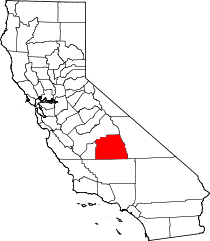
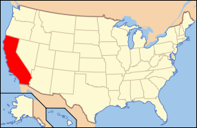
Tulare County, California
| County of Tulare Garden of the Sun |
|||
|---|---|---|---|
| — County — | |||
|
|||
 |
|||
 |
|||
| Country | United States | ||
| State | California | ||
| Region | Central California | ||
| Metro area | Visalia Metropolitan Area | ||
| Incorporated | 1852 | ||
| Named for | Tulare Lake | ||
| County seat | Visalia | ||
| Incorporated cities | 8 | ||
| Government | |||
| - County Administrative Officer | Jean Rousseau | ||
| - Board of Supervisors |
Supervisors
|
||
| Area | |||
| - Total | 4,863 sq mi (12,595.1 km2) | ||
| - Land | 4,824 sq mi (12,494.1 km2) | ||
| - Water | 15 sq mi (38.8 km2) | ||
| Highest elevation[1] | 14,505 ft (4,421 m) | ||
| Population (2000) | 368,021 | ||
| - Density | 76/sq mi (29.3/km2) | ||
| Time zone | Pacific Standard Time (UTC-8) | ||
| - Summer (DST) | Pacific Daylight Time (UTC-7) | ||
| Area code(s) | 559 | ||
| Website | co.tulare.ca.us | ||
Tulare County is a county located in the Central Valley of the U.S. state of California, south of Fresno. Sequoia National Park is located in the county, as are part of Kings Canyon National Park, in its northeast corner (shared with Fresno County), and part of Mount Whitney, on its eastern border (shared with Inyo County). As of 2000 the population was 368,021; as of 2007 the population estimate was 429,006. Its county seat is Visalia. The county is named for Tulare Lake, once the largest freshwater lake west of the Great Lakes and now drained. The site is now in Kings County, which was created in 1893 from the western portion of the formerly larger Tulare County.
Contents |
History
Tulare County was formed from parts of Mariposa County in 1852. Parts of the county's territory were given to Fresno County in 1856, to Kern County in 1866, to Inyo County in 1866 and Kings County in 1893.
Comandante Pedro Fages, while hunting for deserters in 1772, discovered a great lake surrounded by marshes and filled with rushes which he named Los Tules (the tules). It is from this lake that the county derives its name. The root of the name Tulare is found in the Mexican word tullin, designating cattail or similar reeds.
The infectious disease Tularemia caused by the bacterium Francisella tularensis is named after Tulare County.
Economy
Tulare County reports show one of the highest percentages of poverty (as a percentage of population) in California. [2]
Milk brings in the most revenue for the county, typically more than US$ 1 billion a year annually. Oranges, grapes, and other cattle-related commodities also bring in hundreds of millions of dollars annually.
In 2001, Tulare became the most productive county in the U.S. in terms of agricultural revenues at US$ 3.5 billion annually, surpassing Fresno County's US$ 3.2 billion, which held the spot for over two decades.
Due to the importance of agriculture in the county as well as its location in the state, the city of Tulare (in Tulare County) has been the home of the annual World Ag Expo,[3] the world's largest agricultural exposition, since 1968.
An influential contribution to Tulare County is minor league sports like the baseball Visalia Rawhide of the class-A level California League (an affiliate to the Arizona Diamondbacks), two teams of the Minor League Football Association in Tulare and Visalia, and four teams of the Central California Basketball League based in Porterville.
Geography
According to the U.S. Census Bureau, the county has a total area of 4,823 square miles.
Cities, towns, and unincorporated communities
|
|
|
Adjacent counties
- Fresno County - north
- Inyo County - east
- Kern County - south
- Kings County - west
National protected areas
- Blue Ridge National Wildlife Refuge
- Giant Sequoia National Monument (part)
- Inyo National Forest (part)
- Kings Canyon National Park (part)
- Pixley National Wildlife Refuge
- Sequoia National Forest (part)
- Sequoia National Park
Transportation infrastructure
Major highways
 State Route 43
 State Route 63
 State Route 65
 State Route 99
 State Route 198
Public transportation
Tulare County Transit provides a countywide bus service linking the population centers. A connection to Delano in Kern County is also operated.
The cities of Tulare, Porterville, and Visalia have their own local bus services.
Greyhound and Orange Belt Stages provide long-distance, intercity bus service.
Airports
The Visalia Municipal Airport has very limited commercial passenger service. Sequoia Field, just north of Visalia, is a county-owned general aviation airport.
The nearest full operation commercial airports are Bakersfield's Meadows Field Airport to the South, and Fresno's Fresno Yosemite International Airport to the North.
Demographics
As of the census[4] of 2000, there were 368,021 people, 110,385 households, and 87,093 families residing in the county. The population density was 76 people per square mile (29/km²). There were 119,639 housing units at an average density of 25 per square mile (10/km²). The racial makeup of the county was 58.08% White, 1.59% Black or African American, 1.56% Native American, 3.27% Asian, 0.11% Pacific Islander, 30.79% from other races, and 4.60% from two or more races. 50.77% of the population were Hispanic or Latino of any race. 6.2% were of American, 5.7% German and 5.0% English ancestry according to Census 2000. 56.3% spoke English, 38.9% Spanish and 1.1% Portuguese as their first language.
There were 110,385 households out of which 44.9% had children under the age of 18 living with them, 58.1% were married couples living together, 14.5% had a female householder with no husband present, and 21.1% were non-families. 17.1% of all households were made up of individuals and 7.7% had someone living alone who was 65 years of age or older. The average household size was 3.28 and the average family size was 3.67.
In the county the population was spread out with 33.8% under the age of 18, 10.6% from 18 to 24, 27.6% from 25 to 44, 18.2% from 45 to 64, and 9.8% who were 65 years of age or older. The median age was 29 years. For every 100 females there were 100.0 males. For every 100 females age 18 and over, there were 97.7 males.
The median income for a household in the county was $33,983, and the median income for a family was $36,297. Males had a median income of $30,892 versus $24,589 for females. The per capita income for the county was $14,006. About 18.8% of families and 23.9% of the population were below the poverty line, including 32.6% of those under age 18 and 10.5% of those age 65 or over.
Crime Statistics
(reported by the sheriff's office or county police)[5]
- Murders: 3
- Rapes: 40
- Robberies: 87
- Assaults: 411
- Burglaries: 1328
- Thefts: 2117
- Auto thefts: 11
Politics
| Year | GOP | DEM | Others |
|---|---|---|---|
| 2008 | 56.9% 44,729 | 41.6% 32,670 | 1.5% 1,226 |
| 2004 | 66.2% 65,399 | 32.9% 32,494 | 1.0% 967 |
| 2000 | 60.2% 54,070 | 36.8% 33,006 | 3.1% 2,742 |
| 1996 | 53.9% 46,272 | 38.1% 32,669 | 8.1% 6,905 |
| 1992 | 45.7% 40,482 | 35.2% 31,188 | 19.1% 16,883 |
| 1988 | 59.6% 46,891 | 39.0% 30,711 | 1.4% 1,067 |
| 1984 | 63.9% 51,066 | 35.1% 28,065 | 1.0% 812 |
| 1980 | 58.3% 41,317 | 35.5% 25,155 | 6.2% 4,374 |
| 1976 | 54.5% 31,864 | 43.7% 25,551 | 1.8% 1,027 |
| 1972 | 59.9% 36,048 | 36.2% 21,775 | 3.9% 2,327 |
| 1968 | 52.2% 29,314 | 39.5% 22,180 | 8.4% 4,695 |
| 1964 | 39.8% 22,527 | 60.1% 33,974 | 0.1% 51 |
| 1960 | 54.0% 29,456 | 45.6% 24,887 | 0.4% 239 |
Tulare is a strongly Republican county in Presidential and congressional elections. The last Democratic candidate for President to win a majority in the county was Lyndon Johnson in 1964.
Tulare is part of California's 21st congressional district, which is held by Republican Devin Nunes. In the State Assembly, Tulare is in the 29th, 30th, 31st, and 34th districts. The 31st is held by Independent Juan Arambula, while the 29th, 30th, and 34th are held by Republicans Michael Villines, Danny Gilmore, and Connie Conway, respectively. In the State Senate, Tulare is part of the 16th and 18th districts, which are held by Democrat Dean Florez and Republican Roy Ashburn respectively.
Lakes
|
|
Rivers
|
|
Parks
|
|
Sequoia National Park
Sequoia National Park is a national park in the southern Sierra Nevada, east of Visalia, California, in the United States of America. It was established in 1890 as the second U.S. national park, after Yellowstone National Park. The park spans 404,051 acres (1,635.14 km2). Encompassing a vertical relief of nearly 13,000 feet (3,962 m), the park contains among its natural resources the highest point in the contiguous 48 United States, Mount Whitney, at 14,505 feet (4,421 m) above sea level. The park is south of and contiguous with Kings Canyon National Park; the two are administered by the National Park Service as one unit, called Sequoia and Kings Canyon National Parks.
See also
- Tulare Lake
- Tule
References
- ↑ Mount Whitney in the Sierra Nevada Mountains, on border with Inyo County.
- ↑ US Census 2005
- ↑ World Ag Expo
- ↑ "American FactFinder". United States Census Bureau. http://factfinder.census.gov. Retrieved 2008-01-31.
- ↑ "city-data-Tulare_County-CA". analyzed data from numerous sources. http://www.city-data.com/county/Tulare_County-CA.html. Retrieved 04-07-2009.
External links
- Tulare County official website
- Tulare County Agricultural Commissioner/Sealer official website (with Annual Crop and Livestock Reports)
 |
Fresno County | |
||
| Kings County | Inyo County | |||
| Kern County |
|
|||||||||||||||||
|
|||||||||||||||||||||||